Agriculture could be biggest user of commercial drones
From Star Tribune, July 25, 2015; Tom Meersman; direct link to Star Tribune:

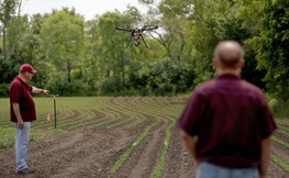
(Above)Sr. field technician Tim Baker position the camera on a drone before agricultural test flight at the U's Rosemount Research and Outreach Center.
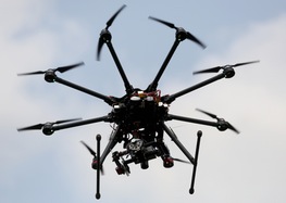
At the end of a dirt road in Dakota County, University of Minnesota researchers lean over the back of a pickup truck and tinker with a black, eight-armed machine about the size of an office wastebasket.
Minutes later tiny rotor blades on each arm whir into action, their whine sounding like a huge swarm of bees as the octocopter shoots vertically 200 feet into the air and buzzes down the field on a mission.
The remote-controlled drone is now at the forefront of sophisticated technology in agriculture — in this case to learn whether low-flying specialized cameras can detect soybean aphids, one of the most serious insect pests in the Upper Midwest.
“Unmanned aircraft vehicles are really going to change the way that we actually do agriculture,” said Ian MacRae, professor of entomology at the University of Minnesota, Crookston, who is one of the researchers. “This is really a very exciting time.”
Remote sensors on drones could scan crops for health problems, monitor hydration and growth rates and locate disease problems. The drones could help with “precision farming,” a growing practice where farmers apply pesticides and fertilizers in a more timely way to small portions of a crop rather than an entire field.
The Association for Unmanned Vehicle Systems International estimated in a recent report that drones will create more than 34,000 manufacturing jobs and 70,000 new jobs in the United States in the next three years, with an economic impact of more than $13.6 billion, growing to more than 100,000 jobs and $82 billion by 2025.
Agriculture is expected to make up 80 percent of the potential market for drones in the near term, according to the report. And the growth is expected to take off after the Federal Aviation Administration finalizes regulations on commercial use of drones, probably late next year.
No one knows exactly how many drones are already being used in Minnesota. But ads for them appear prominently in farming magazines, and flight demonstrations have drawn crowds of growers at farm shows.
“I’d say you could probably find somebody in each county in Minnesota who’s using one,” said Matt Rohlik, founder and CEO of Midwest Aerial Technologies in Renville, a recent start-up that works with drones in agriculture and other industries.
Companies such as Rohlik’s must get permits and follow certain rules, such as flying below 500 feet and only during daylight hours and staying out of airport flight paths. However, farmers who own drones are considered “hobbyists” by the FAA and don’t need permits.
Jerry Johnson, CEO and founder of Farm Intelligence² in Mankato, estimates that thousands of farmers in the Midwest corn belt already own drones and that dozens of firms have permits to fly them. His company’s main business is to analyze the pictures and data that specialized cameras provide as drones fly them over fields.
Some people fear that drones may be used to invade their privacy, or may be unsafe if flown in urban areas, Johnson said. But those issues are minimal in cornfields or rural areas.
“Agriculture is a good fit for drones right now,” he said.
 Senior field technician Tim Baker, right, and U
professor Ian MacRae watched as a drone landed at the U's Rosemount Research
Center. In the recent field trial, the drone took only about five minutes to
make four passes on a pre-programmed flight 65 meters above the field, and
returned to land at the flip of a switch.
‘In the first inning’
For all the promise of the new technology, many people familiar with drones say that hype about them has eclipsed the fact that their actual uses are still quite limited in agriculture.
“We’re in the first inning, and there’s a lot of work that needs to be done yet,” Johnson said. “If you simply fly over a wedding or something and take some pictures, that’s fine, but if you’re going to do something with the data, it is more complicated.
” Right now, there’s a “bottleneck” when it comes to interpreting data from drones, but they will eventually have great value if they can pinpoint problems in portions of fields, such as shortages of nitrogen for corn, said Dan Kaiser, a University of Minnesota Extension specialist in soil nutrient management.
Hamid Mokhtarzadeh, an aerospace fellow at the U who has been part of the soybean aphid research, said one challenge is that using drones requires pulling together various expertise and strands of technology.
“All the parts are there,” he said, including the UAVs, cameras, remote sensing and “image stitching software” that allows hundreds of images of different parts of a field to be combined. “All of these need to come together with analysis so we can say something about the health of the crops.
” Because much about UAVs is new, there’s a broad range of costs for individual farmers. Simple quadcopters with digital cameras cost less than $1,000. Other systems range from $2,000 to $30,000 or more, depending on whether they come with sophisticated sensors and software that measure moisture content and light reflectivity from plants.
Johnson said his firm performs close analysis of data from drones, with costs varying from 70 cents to $3 per acre, depending on the type and depth of the analysis.


